Archives, Knowledge, and Information

Two things from my social feeds this week:

First, James Somers’ “Keepers of the Secrets” in the Village Voice reflects provocatively on the value of archival materials that fall between the cracks of digital search algorithms, accessible only by physical presence. NYPL archivist Thomas Lannon serves as the story’s central figure, displaying both a vast knowledge of the contents of box after box of documents, but also an equanimity about the significance of any one in particular:

That is the paradox of being an archivist. The reason an archivist should know something, Lannon said, is to help others to know it. But it’s not really the archivist’s place to impose his knowledge on anyone else. Indeed, if the field could be said to have a creed, it’s that archivists aren’t there to tell you what’s important. Historically momentous documents are to be left in folders next to the trivial and the mundane — because who’s to say what’s actually mundane or not?

That humility reflects that research in the archives is ideally a symbiosis of archivist and historian. One makes materials accessible, and the other brings contextual knowledge to find meaning in them, relating them to other documents, other narratives, other questions:

Diving into this well is one of the positive side effects of a less-than-detailed finding aid. “The best the finding aids give you is ‘Letters, 1921–1937’,” Syme said. “‘I guess I have to look at every single letter?’ Yeah, you do.” The need to pore through boxes forces you to connect with them. Syme described this as one of the few kinds of formal research left. You can’t google — you have to think about what you want. You have to talk to an archivist, and find the right box, and go through that box.

What I liked best about Somers’s article was the way that, without having to state it directly, he showed the poverty of our present conception of knowledge as mere information. What can be Googled isn’t all that matters.

The information age, unfortunately, has not left archival practices alone. While the volume of paper finding its way to archives after its bureaucratic utility is exhausted has grown, the development of archival best practices for rendering that paper accessible to researchers has purged most qualitative or critical analysis from the work:

A 2005 paper titled “More Progress, Less Process” was a wake-up call to the field. “Truly, much of what passes for arrangement in processing work is really just overzealous housekeeping, writ large…. Pointing out that as much as 80 percent of the archivists’ time was spent “refoldering,” the paper offered shortcuts that, it claimed, would make more collections available without sacrificing much in the way of intellectual accessibility.

“MPLP,” as the paper’s doctrine became known, went on to be the rallying cry of the field, even as it seemed to transform the archivist from an assiduous historian into a corner-cutting technocrat, rushing to get linear feet of record out the door (“linear feet” is an obsession in the world of archives; one standard box of folders is just over one linear foot). Indeed, most archivists got their start because they liked poring over archives. The ethos of MPLP was to read as little of a collection as you possibly could, while still ensuring that you made it usable for research.

As a former practicing historian, I recall a great frustration when my research “productivity” was evaluated by quantitative social scientists whose working assumption was that “data” is standardized and available, awaiting analysis. Maybe not everybody gets this work.

Of course, researchers can do great things make the knowledge in archives accessible in the digital stream of information. My second read to pass along is a great example, the 80s.nyc project by Jeremy Lechtzin and Brandon Liu (described here) to digitize and geocode photos, taken for tax assessment purposes, of virtually every building on every block in New York City in the 1980s. It’s easy to say that the city’s changed since the 1980s; this kind of work, by starting with archives to make information, helps you to see it too.

More on the Sharing Economy

Thorough analysis by Tom Slee in Jacobin of the controversy surrounding municipal regulation of short-term rental-by-owner and ride-share companies, something I’ve discussed, albeit more briefly and considerably less diplomatically.

I think the key to understanding the issue is to think about the way that the highly capitalized tech companies are deploying a self-representation that brings them into line with a legacy of community cooperative enterprises:

the sharing economy invokes images of neighbourhoods, villages, and “human-scale” interactions. Instead of buying from a mega-store, we get to share with neighbours.

that obscures their motive: extracting profit by opening unregulated markets in housing and labor:

Lyft moved instead to offer something closer to an alternative taxi: they kept the language of sharing in the company slogan “Your friend with a car,” but Lyft is now clearly positioned as a source of income for its drivers, who increasingly look like employees who have to supply their own cars. Uber started off as tech-driven limo service, but has moved into the “sharing” space to cut prices.

Both Uber and Lyft have adopted controversial tactics like “surge pricing,” in which the price of a ride rises in busy times or during bad weather conditions in order to attract more drivers on the road, a move that places market incentives at the center of their business model. While Lyft originally called its fares “donations,” it has now abandoned the pretense.

And, while the companies’ rhetoric merges the legacy of urban cooperatives with the gloss of technological innovation, they’re certainly not above some good old-fashioned exploitation of people on the fringes of the labor market.

The Google-funded house cleaning service Homejoy is a partner of Peers, but its cleaners are, according to Forbes, people who need to show proof of employment to receive government assistance, recruited through municipal employment services. Meanwhile delivery giant DHL has launched itsMyWays delivery service, powered by “people who want to deliver parcels and earn some extra money.” TaskRabbit and others call their workers “micro-entrepreneurs,” but that is a poor description of precarious piecework. The preferred phrasing of “extra money” harks back to women’s jobs of 40 years ago. And like those jobs, they don’t come with things like insurance protection, job security, benefits — none of that old economy stuff.

As Slee makes clear, the sharing economy is a particular sector of the new metropolitan economy that is driven by the consumption choices of affluent and networked professionals. The companies don’t facilitate the sharing of skills or resources among equal members of a community, they exploit employees made more desperate by the collapse of living wages and the arms race in the cost of food and housing driven by the consumption power of the wealthy. Cooperative enterprise certainly has a place in many imaginations of better urban living, and indeed there are many historical examples of it that we can draw on today. The sharing economy isn’t one of them.

Hindsight

A find from the Manuscript, Archives, and Rare Books Library at Emory. This is from a market analysis study conducted by a consulting firm on behalf of a prospective developer of a downtown retail complex in 1954:

It is perfectly clear that the completed expressway will vastly improve the competitive position of Atlanta’s downtown retail district. It will bring the heavy population of the north and south areas much closer to the central stores and shops. By putting the huge retail magnet of the downtown as close to these populations as the expressway itself, figuratively speaking, it will serve further to decrease the possibility of successful, large-scale regional competition (which would no longer have a locational advantage except with respect to the relatively low-density immediate suburbs). The possibility of building up a large suburban market by pulling customers from a broad area is considerably lessened when the lines of attraction are cut by an expressway that can get the customers downtown to the major stores in a matter of only a few minutes.

OK then….

Obviously we know that this particular gambit worked out to be, as the kids say, an epic fail. But it raises a set of questions that aren’t so obviously answered. For one, the narrative of white flight and capital exodus from central cities was not a linear process, and within regional real estate markets, there were just as many folks betting on downtown for much of the postwar era. In Atlanta, part of that bet came from the certainty that business leaders like C of C (and later Mayor) Ivan Allen, Jr. had that federal highway and urban renewal policies were a tool at their disposal to make their property more valuable by manipulating and remaking property around it. But I wonder increasingly how much of that certainty was fed by these kinds of market reports. Armed with a set of market reports that said “bail out and buy tracts in the suburbs,” would downtown real estate holders have done differently? Many, including the Rich’s Department Store company began to hedge their bets by acquiring land along the proposed Perimeter Highway route (I-285), but for most of the 1950s professed publicly and planned around the premise that their downtown store was the company’s heart, soul, and meal ticket.

Had these interests bailed, instead of seeking to leverage urban renewal to protect and enhance their property, would central Atlanta be better off today? It’s hard to argue that the investment of millions of development dollars downtown in the era of white flight was a bad thing, but it’s important to recognize two things: the cyclical and repetitive nature of these projects, and the process through which redevelopment priorities were set. Atlanta’s downtown and adjacent areas bear the imprints of successive waves of “improvements” all promising what this report did, without delivering the anticipated returns, and while preventing the development of housing that could alleviate the overcrowding of many of the city’s most impoverished black neighborhoods. Irene Holliman raises important questions in an article in the Journal of Urban History that links the 1966 Summerhill Riot in the area near Fulton County Stadium to the disruptive effects of giant urban renewal projects conceived and executed without regard for the needs of the local public, whose increasingly militant opposition to conditions of poverty and overcrowding was turned against their communities’ very survival by urban renewal authorities who enthusiastically accepted that slum neighborhoods were intolerable, but balked at replacing the housing they destroyed in the name of renewal.

Holliman writes that while the riots shook the city’s complacent image as “too busy to hate,” they

should have come as no surprise to Mayor Allen, city aldermen, or any of the local urban renewal committees. The Council on Human Relations of Greater Atlanta… did not blame SNCC for the riot. In a news release, the council members talked about the city’s failure to delivers services, stating, “SNCC members are not responsible for [creating] parking spaces for 4,000 cars [for stadium goers] in the middle of an area which has no parks for children to play in” (Holliman, Irene V. 2009. “From Crackertown to Model City? Urban Renewal and Community Building in Atlanta, 1963—1966.” Journal of Urban History 35 (3) (March 1): 380. doi:10.1177/0096144208330402.).

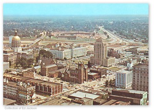
Strangely enough, residents of Summerhill weren’t happy about having this

FultonCounty14

dropped next to their neighborhood. From the point of view of downtown, however, the recently-cleared parcel at the confluence of two interstate expressways was a perfect location to put a stadium to attract a ballclub that would flatter the vanity of local elites who had been clamoring for their city to join the proverbial big leagues for some time. If the interstates and the ocean of parking lots was the price to pay for drawing suburbanites and their wallets back into central Atlanta, even if only for 81 games each summer, the costs of the project were sufficiently remote that they seemed negligible.

April, 1964, from Georgia Info

April, 1964, from Georgia Info

The anthropologist James Scott would indict these projects as “Seeing Like a State–substituting the 30,000-foot view of central authority (be it public or corporate, or, as in Atlanta, a regime linking the two) for the locally-situated knowledge of residents. Urban renewal that involved these residents at the core of the planning process would have alienated the city’s business and banking establishment, but might have been able to use a more modest stream of funds to meet basic human needs. Had the city’s establishment not clung to the hope of making central Atlanta profitable, it might have had a better chance of becoming habitable.

Tourism in Historical GIS

I’ve always been a bit regretful for not training myself to use Geographical Information Systems (GIS) in my research earlier in my career, when I had more time to master the technology. GIS is not a method that lends itself to half-assed approaches; it doesn’t add much to a study unless it is carefully applied, and requires considerable care in the framing of research questions and in the selection of data to be inputted. It can pay off magnificently, as in Colin Gordon’s study of the economic hollowing out of Saint Louis, and historians like Amy Hillier (with the Mapping DuBois project at Penn) and John Logan (with the Urban Transition Project at Brown) offer great examples of the deep and collaborative effort required to render historical urban maps into usable GIS shapes and to assemble broad and systematic data sets that can be mapped. These efforts hold tremendous promise for considering the spatial dimensions of urbanization processes (which, in my definition, includes both traditional centripetal urbanism and the related pattern of suburban sprawl) and the relationship of urbanization processes to racial, gender, and socioeconomic phenomena.

As David Bodenhamer argues, GIS, despite its usefulness for historians concerned with the spatiality of the past, have had a hard time fully integrating the method into their work. The reasons for this are complex, and, Bodenhamer argues, entail technological, data access, and conceptual barriers to integrating GIS within the disciplinary practices of historians (see Amy Hillier in the Journal of Planning History for more on this.

Aside from the somewhat daunting technological learning curve, users face the problem of access to software. The most common professional GIS platforms are proprietary, and limited by and large to Windows operating systems, a problem for the considerable numbers of academic researchers on Mac OS. There is, however, an open-source and free GIS client that runs on Mac OS (as well as Windows and Linux) called Quantum GIS (QGIS).

One of the benefits of being on fellowship is the opportunity to “steal” a bit of my own time for professional development, and playing with QGIS has been, if not yet professionally rewarding, quite in interesting use of an hour here and there. I’ve begun working through a few online tutorials for QGIS that walk the user through some basic tasks–selecting and modifying a shapefile (the data that creates a visual map) and “joining” tabular data (e.g. demographic data or an inventory of toxic releases) to the shapefile so that the map presents a visual argument about some aspect of social reality. The tutorial I’ve been using (from Len de Groot at the University of California-Berkeley’s Knight School of Journalism) includes a  data set for download; the National Historical GIS project at the University of Minnesota provides a free platform for accessing GIS shapefiles and census data tables that include data fields allowing the tabular data to be joined to the shapefile.

Another tutorial series from Baruch College also looks promising, and since QGIS is open-source, using it allows one to connect to the communitarian trend in software use and to a vast array of resources for self-training at little or no cost.

For further reading on GIS in historical research, check out:

Knowles, Anne Kelly, and Amy Hillier, eds. Placing History: How Maps, Spatial Data, and GIS Are Changing Historical Scholarship. 1st ed. Redlands, Calif: ESRI Press, 2008.
Logan, John R., Jason Jindrich, Hyoungjin Shin, and Weiwei Zhang. “Mapping America in 1880: The Urban Transition Historical GIS Project.” Historical Methods 44, no. 1 (March 2011): 49–60. [for that matter, two special issues on the Minnesota Population Project from 2011 are worth a look]

Social Science History, Fall 2000